Contents
Missouri and Hispanics: Road to the Pacific
As a result of this Spanish exploration, maps were made that would be used in the subsequent preparation of the Lewis and Clark Expedition.
+ Hispanic Roots
It was the first expedition and carried out in 1795
Most of the journey of Lewis and Clark’s trip to the Pacific, had the collaboration and Spanish maps
The U.S Expedition was based on Spanish maps. Much of the journey was done with the information provided by the Spanish expedition.
In search of the unknown tribe of the Mandan, suspected of Europeans among them
They explored the area
The information that was collected and the data were reflected in maps that were of great help to the later Lewis and Clark expedition based on the previous Spanish expeditions.
They took the experience and the maps made by the Spanish expeditions. The Spanish Manuel Lisa collaborated for 2 years in its previous preparation.
Spaniards before Lewis and Clark
The Spanish visited the Missouri area in 1795, 10 years before them
Until 1803, Louisiana was Spanish territory. As early as 1795, a Spanish expedition visited most of the Missouri River route, reaching North Dakota. This expedition drew maps of the Missouri that were later used by the Lewis and Clark Expedition.
They made maps
The Hispanic expedition led by Evans drew such precise maps that the later Lewis and Clark expedition could only complete it with minor tributaries.
Explorations of the route to the Pacific
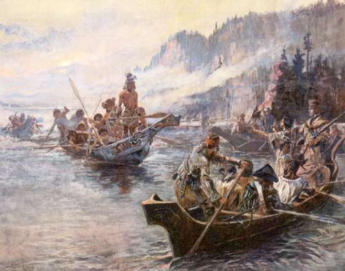
Painting on the Lewis and Clark expedition
North American mythification of the Lewis and Clark expedition on its journey up the Missouri River. They are presented as the first in those lands.
Evans with Hispanics
Previously a Spanish expedition with Evans and Mackay traveled the Missouri.
The reason for the mission was to discover a tributary of the river that reached the Pacific Ocean.
At this time, Spain to avoid war with England has abandoned 2 of its Fortified Bases in the Pacific Ocean: San Lorenzo de Nutka in Canada and Núñez Gaona (Neah Bay) in the territory of now Washington State.
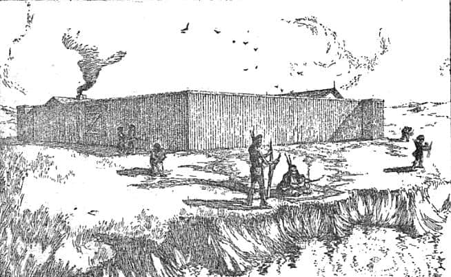
Mackay builds the Fall Outpost in the Platte River area of Arkansas. Evans occupies the abandoned post of Jusseaume, takes it into possession for the Crown of Spain and renames it for Spain as Fort Mackay in North Dakota.
He was also sent to associate with the Pocas, Arikaras, and Sioux on the White River in South Dakota. There he takes possession of Truteau’s winter post, called by the Spanish Casa de Ponca in South Dakota.
A Spanish route to the Pacific
The Mandan Indians were visited, studying their life and customs
The Spanish expedition had the objective to find a route towards the Pacific crossing from Luisana and crossing the Missouri River. For his part, Evans was trying to find a Mandan tribe that supposedly spoke Welsh.
The Mandan were a tribe that lived between North and South Dakota with a language and customs somewhat different from those of their environment. Their boats were reminiscent of Welsh boats and their houses resembled European ones. Their skin color was lighter than that of their neighbors and they were suspected of European origin, by Welsh legends.
Evans began his expedition up the Missouri from Nebraska Fort San Carlos (Fort Charles) to the Mandan and Hidatsa villages in North Dakota. He failed to find clear evidence of his theory of white Welsh descendants in the area.
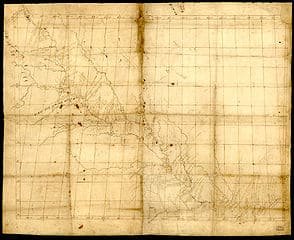
The Missouri River explored by Evans
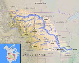
Tour the states of Missouri, Kansas, Nebraska, South Dakota, North Dakota, Montana
Evans Expedition Map
The Spanish expedition through Missouri
During the Spanish expedition of recognition of the Missouri more than 2000 km were covered. James Mackay with the collaboration of John Evans, a map of the area was made. This map was the basis for the Lewis and Clark Expedition and he would be of great help. At least 2/3 of the expedition route had already been previously visited by Spanish expeditions, years before.
Heading to the Pacific
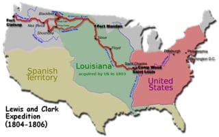
Lewis and Clark expedition in search of the Pacific Ocean. Louisiana and the Missouri River were already explored by the Spanish
Expedition route
A river that was not explored by the Spanish until 1795. But with this exploration they laid the foundations and provided information about the Indian tribes. He created the maps that would allow the Lewis and Clark expedition to continue their exploration to the Pacific.
Manuel Lisa explorer and merchant
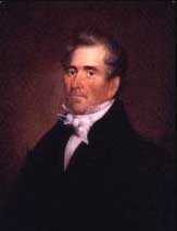
A born entrepreneur, this Spaniard had already been born in San Luis de Missouri. His knowledge of the area was fundamental
The purchase of La Luisiana from the US changed his life. When Louisiana passed into the hands of the United States, he found himself a US citizen. He began by negotiating between New Madrid and Orleans in Louisiana. He explored the Missouri and built the first fort in Montana (Fort Manuel) or Fort Raymond.
Restless, he tried to teach agriculture to the Sioux Indians. He continued to explore the region discovering Yellowstone. He also built “Fort Lisa” in North Dakota. In Nebraska he built a second “Fort Lisa” near Omaha, so he could trade.
Knowledgeable about the indigenous tribes of Kansas and Missouri, he succeeded in getting them to side with the Americans in the war with the English.
The purchase of the Louisiana territories by the U.S suddenly made him a US citizen. Restless, he tried to teach agriculture to the Sioux Indians. He got some of the Native American tribes in Kansas and Missouri to side with the Americans.
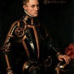
Manuel Lisa
Manuel Lisa Fort in North Dakota
He supported the Lewis and Clark expedition, and advised them during the two years of its preparation
Experienced man
Explorer and merchant of Spanish origin
Manuel Lisa was a Spanish merchant who participated for 2 years, in the advice and preparations of the Lewis and Clark expedition. For different reasons he refused to participate in the expedition. The merchant Lisa who knows the area and the Indian tribes. In one of his forts in Dakota the Lewis and Clark expedition rested.
The other American plans
From King of Spain to President
Inform and convince of the change to the new President of the United States
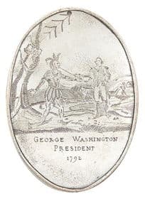
The expedition carried a more complicated mission than it seemed. After 300 years in which the Great White Father was the King of Spain, they had to convince the indigenous people that he would now be the President of the United States.
For this, in addition to gifts and flags, they took other accessories. The expedition wore specially minted medals to show that now the Great White Father was no longer the King of Spain. The gift to the Indian Chiefs of these medallions was made whenever possible.
They also had to prove that they were the most powerful. They carried the best weapons of the time, .45 caliber repeating rifles that could kill medium-sized animals with a single shot.
This expedition was more successful than the Pike, whose group was arrested as a spy by the Spanish. Pike reached the border area of Kansas and Missouri. He made the Pawnee Indians remove a Spanish flag and put up the American one. After being detained by the Spanish, he was taken to Santa Fe where he was detained until he was repatriated.
The Great White Father
Specially minted coins, indicating that the new Great White Father was now the American President
Spain after Lewis and Clark
The exploration was going to cover explored territories and Spanish sovereignty. For this reason, on several occasions they are sought to stop them
The Spanish, upon learning in 1804 that the expedition was going to territories claimed by the Spanish Crown, sent Pedro Vial and 50 dragons. Although these reached Nebraska, the territory of the Pawnee Indians, they did not reach them.
There was a new Spanish attempt to take them prisoners in 1805. Pedro Vial left Santa Fe with about 100 soldiers but was attacked in Colorado by well-armed Indians and had to return.
Later, in 1806, the largest Spanish troops in this area, 600 soldiers, militiamen and even friendly Indians, were sent to arrest them.
Cuera Soldiers
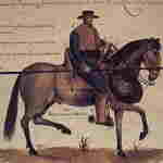
Cuera dragon, Spanish soldier on horseback, guardian of the border
Spanish expedition of Cuera Dragons to look for and apprehend them
The Jefferson Plan (1804)
The new White Chief would no longer be the King of Spain
All those Indians who traded with the Spanish had to be treated well. They were to be informed that the Great White Father would be the United States. That is why they carried abundant US flags. They wanted the Kiowas, Caddos, Comanches, and Witchitas to trade with the Americans just as they had with the Spanish and French.
Jefferson gave Lewis and Clark the map that the Evans Spanish Expedition had made and the valuable comments on what they would find, later, according to what he had heard from the Indians of their explorations in the Pacific area.