Contents
Maps: Why were they so valuable?
When Spain ruled the seas, and this was for several centuries, a real treasure was to have one of her maps. It allowed to know 2/3 of the world. They were highly coveted by other countries. They were information, they were power, savings, being able to make travel forecasts, etc.
+ Hispanic Roots
One of the first maps by Juan de Ribeiro that includes North America. All coastal explorations of the time were reflected in it.
A treasure on paper
These and the Navigation Charts could be used for future safe expeditions, since they could indicate the places where to find water and fresh food, basic to be able to survive.
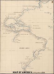
This was the coast of America
The area of the future 13 English colonies, almost 100 years before their establishment
Thanks to the explorations of Ponce de León, Álvaro de Pineda, Esteban Gomez, Ayllon, etc. Spain was able to determine the geography of the Atlantic Coast already in the first half of the 16th century.
Spanish maps were strategic information that reached only a few. The Casa de Contratación de Sevilla, watched over the captains and pilots who owned them, so that they did not go to other foreign countries
The first maps of America
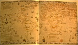
Diego Ribera makes the first map
He is the Royal Spanish Cartographer, which is why Diego Ribera made the first map that included the coast of North America up to Newfoundland. This map is made in the year 1529 and summarizes the Spanish explorations of North America
Territory of the future 13 colonies
It is often unknown that Spain made almost 100 expeditions to the territories that are now the United States. For this reason, already in 1529, the first map could be made thanks to the explorations of Ponce de León, Álvaro de Pineda, Esteban Gómez, Ayllon, etc.
Spanish Map of the World (1529)
Esteban Gómez arrives in Terranova
Esteban Gómez’s expedition that traveled the Atlantic coast of the territories that today are the United States and Canada, allowed to expand the knowledge of the area. Thanks to him and other Hispanic explorers, Diego Ribero was able to make this map of the World in 1529.
Map of Juan de la Cosa (1500)
Map of Guanahani and its surroundings
The famous Spanish explorer also drew a map of Guanahani
First outline map of America
Already from the first years of the exploration of America, important data was provided.
Cantino Map
Cantino Map (1502)
The Florida Peninsula already appears
The Italian spy collected information from the natives of the islands and drew Florida before Ponce de León visited it in 1513.
Although that map reached the Duke of Ferrara, it was of little use to him. At that time only Spain and Portugal had a fleet and the means to make voyages across the Oceans.
Map of Diego Gutiérrez (1562)
Details and geographical features of the area
Map of Diego Gutiérrez 1562
This Spanish cartographer made a map where he expanded the information on the North American area, collected by Spanish navigators and explorers.
Apply all known LPs and highlight the known landforms of the area at that time.
Maps, state secrets
A strategic weapon of the Spanish Empire that was hidden from other countries
The results of the explorations of the Spaniards around the world and especially in North America were reflected on maps. These scans were very expensive and their results were highly valued for the valuable information they provided.
The most prestigious royal cartographers concentrated and contrasted the information of the Spanish discoverers who were arriving at the Spanish Court.
England seizes Spanish maps
For centuries Spanish ships traveled the world. They dominated the Pacific crossing and maps were made for their expeditions. This information was a state secret and the Seville House of Navigation controlled and monitored the captains.
The English occupation of Manila already almost at the end of the time of the Spanish Empire, allowed them to seize this treasure. Thanks to these captured maps they were able to know the details of the Pacific. Thanks to them it was possible to carry out the expeditions of Captain Cook, who although he did not discover practically any new territory, he was able to visit them since he knew all the places where he supplied himself and what he was going to find in each territory.
Although the planning of the trip was done by the English Governor of Manila, during the brief occupation. It was enough time for them to seize the maps and the Spanish knowledge obtained during more than 250 sailing through the Pacific Ocean. Thanks to this information England created a new myth, that of the English explorer for his historical account. However the author of the route to follow in the Pacific, was rejected by the English Admiralty, since he was tainted by the theft of the Manila maps.
He would be a young English captain, the one chosen to go down in history as Captain Cook, a false myth had been created.